Submitted!

Our official Expression of Interest to host a CDT in Geospatial AI has been submitted.
Published on February 21, 2023
CDTs AI UKRI EoI
18 min READ
We have submitted our official EoI to UKRI, and managed to do it two days in advance of the deadline! The text of the EoI is shown below:
Summary
Building upon our unmatched multidisciplinary expertise in the cross-over of Artificial Intelligence (AI) and Geospatial Applications we propose a new CDT in Geospatial Artificial Intelligence. The proposed centre will train and develop the next generation of experts in AI, Machine Learning (ML) and Geospatial Science (GS), addressing a clear international and industry need for experts with such skills.
Geospatial data is used by many sectors (e.g., Transport, Construction, Space, Agriculture and Maritime & Shipping) and numerous opportunities exist for AI and geospatial data experts in these sectors. Geospatial data and AI will be at the heart of future fundamental scientific discovery (e.g., in areas from ocean understanding through to space environment physics, where events can affect our natural world), and in applications in Environment (e.g., monitoring, risk assessment and prediction, policy making). Other areas also benefit from Geospatial AI: food & farming; defence; resilience; and population health; etc.
Graduates of our CDT will be future leaders and experts in AI and ML and GS, with a breadth of knowledge around individual expertise and an understanding of motivations and constraints that apply to use cases beyond their own. Our graduates will be empowered to work with/within a variety of organisations, from industry to research centres to NGOs. Our training embeds social and ethical responsibility and a deep appreciation of the importance of environmental sustainability that graduates will champion throughout their careers.
Our training programme is designed to adapt to students from a wide range of disciplines (archaeology, mathematics, social science, law, earth & ocean science, geography, GS, computer science, AI, and engineering). We will help them develop a unique and unrivalled mixed skillset that meets an identified need while supporting flexible work patterns, providing pastoral care, and ensuring all our activities are inclusive. The programme has been co-created with industry involvement shaping plans for taught components, cohort building, and the projects students will undertake. Students undertake a 4-year PhD, with assessed training components embedded throughout all years.
The CDT has four themes which cover the gamut from algorithms that work with data to making informed policy decisions: “Fundamental ML research”, “Applied ML research”, “GS and remote sensing applications”, and “Intelligent policy and decision making”. Individual students will specialise in a single theme but will be trained to understand and communicate at a technical level with people from all four themes. Students put this training into practice within Grand Challenge weeks co-organised with our partners. This aspect exactly highlights why a cohort-based approach is crucial for our CDT.
Research topics will be diverse, for example looking at how: gravitational waves can uncover the earliest moments of the Universe; how ML can be used to help detect, monitor and protect archaeological sites; how new products for monitoring vegetation can be developed with ML and space-based sensors; how AI can be used for mapping and understanding data acquired by autonomous platforms for conservation; how new fundamental ML approaches can be developed to deal with the volume of data and scarcity of labels; and how AI-generated insights might be used to inform and change fishing policy. All these examples have AI/ML and geospatial data at their core.
Our proposal leverages factors unique to the University of Southampton, where only we have a sufficient mass of supervisors across the full breadth of topics of the CDT, coupled with the co-location of strategic external partners who are nationally some of the biggest generators and consumers of Geospatial data. The CDT will allow new collaborations, open new opportunities, and allow us to unlock our potential for the benefit of our students, staff, partners and beyond.
Objectives
The CDT in Geospatial AI will help fill an internationally recognised skills gap between geospatial science and AI and its periphery by:
- Establishing an internationally leading research-training environment that equips students with comprehensive technical skills in Artificial Intelligence and Geospatial Science, and the understanding and transferrable skills to be able to communicate and interact with a broad range of Geospatial AI experts, stakeholders, policymakers and the public;
- Creating a new national training centre drawing across outstanding research, research and training environments, and training expertise at the University of Southampton and our partners;
- Co-developing a cohesive and inclusive training programme with partners that addresses the skills gaps identified by stakeholders and the individual needs of students;
- Taking a cohort-based approach to training that recognises that individuals cannot be experts in every area, but by learning to communicate and work together they can address and solve problems and confront societal challenges;
- Ensuring cohesiveness of the full cohort (in and across years) by providing co-location in year 1, engaging all students in weekly Graduate Research Workshops, and provision of an annual conference and flagship Grand Challenge week;
- Providing a comprehensive programme of collaboration with industrial, government and NGO partners through both formal training and internships;
We will equip students from varied backgrounds with the skills to specialise in aspects of Geospatial AI whilst understanding the bigger picture & its implications. This will be achieved through:
- A new and bespoke training programme with assessed elements that consists of compulsory technical modules, a broad range of specialist technical training, workshops, grand challenges, conferences, internships & placements, peer-to-peer mentoring and transferrable skills training;
- Provision of a uniquely broad range of leading-edge research projects exploiting the expertise of over 50 potential academic supervisors in collaboration with external partners who provide real-world problems and directly engage with supervision of students;
- Creation of a cohesive cohort and career-long network of professional contacts;
- Nurturing the innovation, entrepreneurship, principles, and diverse perspectives needed to confront societal challenges of sustainability and inequality and meet evidenced UK science and industry needs;
- Instilling the capability of understanding motivations and constraints that apply to use cases beyond their own research;
- Embedding a culture and ethos of socially and ethically responsible innovation through training and project design & selection processes.
- Actively encouraging diversity in recruitment, supporting flexible work, and providing pastoral care with effectiveness transparently monitored throughout the CDT’s lifetime.
We will engage with industry, government and NGO partners across sectors, locations and scales by providing a vital national resource for interfacing with experts across all facets of Geospatial AI. We will provide:
- Flexible routes for engagement through provision of partial studentships (depending on organisation size), provision of data and facilities, and contributions to delivery of our training programme including internships/placements;
- Access to “strategic partner” status with higher contribution towards PhD supervision directly from the partner;
- Opportunities for partners to offer research projects and suggest research directions they would find beneficial;
- Routes for industry and partners to have paid access to parts of the training programme for their staff;
- Opportunities for partners to propose and host our flagship Grand Challenge weeks;
- Mechanisms to simplify IP arrangements using standardised agreements dependent on the financial contribution of the partner.
Outline Case for Support
Global geospatial markets are expected to hit >£100bn by 2028 with 12% growth/yr1. Our analysis of doctoral training provision and extensive consultation with industry identifies a major skills gap in Geospatial AI. Our proposal fulfils this demand through partner-co-developed training that nurtures responsible innovation, entrepreneurship, and the diverse perspectives needed to confront societal challenges of sustainability and inequality, meeting UK science, industry, and government need1-7.
1. Centre Vision
 Geospatial AI is the use of AI and machine learning (ML) to efficiently extract actionable information from geospatial data. We propose a national training centre for the next generation of responsible Geospatial AI innovators that is co-created with non-HEI partners and shaped by their needs. Our CDT considers (i) how AI can improve geospatial data analysis, and ii) how geospatial data can help answer fundamental AI questions through the four illustrated themes. Although independent training programmes for geospatial analysis and fundamental AI exist, a joined-up training approach is both lacking and essential to leverage the volume, value, and variety of geospatial data, understand data synergies, bottlenecks and redundancies, and the implications on policy and sustainability. We focus on supporting intelligent policy and decisions; our cohorts investigate aspects of the AI-based pipeline from geospatial data acquisition to generating actionable information & insight, over a broad range of applications. Our graduates will be future leaders in AI, ML and Geospatial Science, capable of understanding motivations and constraints that apply beyond their own use cases. They will not be experts in every facet of Geospatial AI, but rather subject experts in parts of the pipeline & trained to also understand the big picture; this can only be achieved with cohort-based training. They will have the knowledge breadth and skills to communicate effectively with a broad range of Geospatial AI experts, stakeholders, and the public. Our recruitment encourages diverse student backgrounds.
Call Priorities: We address EPSRC/NERC/STFC/ESRC/BBSRC/AHRC & Innovate UK priorities. We focus on (i) “science and research” (enabling new hypotheses, questions and data-driven research looking both in towards Earth & out towards the atmosphere and space, with applications in conservation, modelling, geo-political event monitoring, exploration, space environment physics), and (ii) “environment and energy” (cross-cutting environmental and risk modelling/prediction, monitoring cause-effect loops between policy decisions and change). Our partner remits include themes of defence (augmenting human decisions at scale), understanding agriculture and transport supply chains, and population-scale global health. We address the cross-cutting “government policy” theme through training embedded responsible innovation principles (e.g., how to inform policy with AI, while generating awareness of data/method limitations and potential consequences).
National Need: The 2020-25 Geospatial Strategy2 estimates a UK economic value of £11bn/yr, identifying AI as a key underpinning technology. The Chancellor’s 2022 spring statement6 and the AI Roadmap7 both recognise the need to train new AI experts, prioritising “AI skill building”, “diversity and inclusion”, and “achieving AI and data literacy for everyone”. Our proposal has been shaped through engagement with UK and global industries and NGOs who confirm the urgent need for Geospatial AI expertise and see the lack of skilled people as an inhibitor. We will fulfil both national ambitions and partner needs by training cohorts of AI experts with skills in acquiring, analysing, communicating, and making responsible decisions from geospatial data. Our partners include the National Oceanography Centre (NOC) who aim to accelerate fundamental ocean science with AI; Ordnance Survey (OS) who wish to use AI to make new data products and up-to-date & informative maps; insurance companies in the actuarial sector interested in modelling and managing risk; and sensor manufacturers wanting to incorporate AI into next-generation products. Our target is to have 40 partners with at least £8m support (£2.8m cash) from a diverse range of institutions and sectors. We already have 16 partners offering ~£2.3m (£1.3m cash) support, inc. 13 studentships @ 50%. Engagement with further potential partners (inc. DSTL, Thales, RBC, CEFAS, etc) is ongoing and we expect to meet our target comfortably. Our diverse partner portfolio is essential for the training needed to support the Geospatial AI future of multiple sectors. Our partners enhance our CDT by (i) embedding their needs in co-created training, research, and governance; and (ii) forming a network to disseminate, achieve socioeconomic impact, and provide graduate career paths across sectors, which in turn allows us to attract diverse cohorts. To date, engagement and surveys show strong partner support for our vision, evidence cross-sector need for Geospatial AI experts, and shape our training with contributions of funded internships, 18 PhD topics, 13 lectures and 6 Grand Challenges.
We are uniquely placed to deliver this CDT because we have supervisors across five faculties, with collective world-leading expertise across our four themes and a strong track record of industry collaboration, and who are brought together by our unique hub, Southampton Geospatial. We are co-located with our strategic partners, the NOC, OS and the Office for National Statistics, who are some of the biggest generators, distributors, and consumers of geospatial data in the UK.
2. Student Training Experience
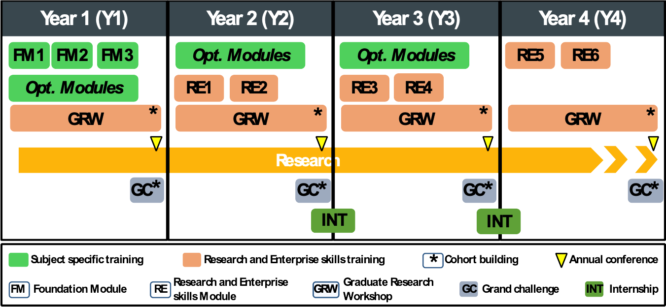
Students enter a four-year PhD programme with enhanced training embedded in assessed taught components. Training requirements must be met for progression. Projects, supervisory teams and students will be selected to ensure diversity and coverage of all four themes within each year group. This overarching cohort and project design are essential to building the big-picture understanding and skills needed to communicate with wide-ranging expertise through regular peer interaction. We encourage interaction across year groups through cohort-wide activities that embed multidisciplinary skills. We will invite CDT alumni to be involved in training and mentoring activities with the other year groups. These cohort activities will be combined with specialised individual training plans tailored to address individual needs. The latter being identified by students and supervisors from a range of training courses organised by the CDT. Our training structure consists of three distinct elements, with assessment in modules and at the annual progression review: (i) subject-specific training, (ii) research and enterprise skills training and (iii) research in practice training. Partner co-developed content ensures graduates with diverse backgrounds will be equipped to address skills gaps. Training is across all years so students can reflect and experiment putting lessons into practice as their projects and networks develop.
Subject-specific: We will recruit students with wide-ranging prior knowledge of Geospatial science and/or AI. Three compulsory Y1 foundation modules developed for this CDT will bring students to the same level: Foundations of Geospatial Science, Foundations of AI, and Foundations of Geospatial AI. Further optional modules (identified with supervisors through individual training plans) will develop either subject-specific or software and data skills. Optional modules will be selected from an existing 100+ module catalogue covering both theoretical and applied aspects of Geospatial AI. Y2 and Y3 students will take at least one subject-specific training module either offered at UoS from existing courses, national training centres, and partners including NCRM and SEPnet. Training in the use of IRIDIS, our HPC facility, will be provided in conjunction with our HPC team and identified national service providers such as ARCHER2/DIRAC and the Hartree Centre. Additional training on advanced topics will be developed and offered to our partners, wider industry, and other CDTs.
Research and Enterprise skills: Our Researcher Development Programme (RDP) and a novel Graduate Research Workshop (GRW) module develop these skills. RDP: Supervisors and students assess generic skills training needs and identify at least 2 modules each year through the University’s existing centres such as the Centre for Higher Education Practice (CHEP), Public Engagement with Research unit (PERu), Public Policy at Southampton, Software Sustainability Institute and FutureWorlds. These cover generic research skills, academic writing, publishing, knowledge exchange, public engagement, software & data carpentry, and translation & impact. GRW: We will develop a new module (24 sessions/yr) which will address research and enterprise training needs that are not covered by RDP, with bespoke interactive workshops and networking events to cover technical and technological application aspects of Geospatial AI and facilitate peer-to-peer learning and interactions both within and across year groups. Repetition is avoided through a 3-year rolling programme, focusing on application (Y1), commercialisation (Y2), and entrepreneurship (Y3). Participation is compulsory and assessed, with students maintaining a learning diary. As part of GRW, students organise an annual conference to present their research to internal and external audiences. GRW will be offered to other doctoral students to facilitate idea cross-pollination. GRW contains induction activities for incoming students with training on responsible innovation, project design, engagement, and sustainability.
Research in Practice is achieved through (i) Grand Challenges (GCs) and (ii) internships and (iii) public engagement. GCs: The annual GC event will be a key training activity to strengthen cohort building and develop generic skills needed to bridge theory and practice. Our GCs are perfect examples of the AI Roadmap’s “moonshots”7, driven by a policy and/or industry need and will be led by external partners. Teams of 4-6 PhD students will address a specific GC over a 1-week period using Geospatial AI techniques whilst demonstrating responsible innovation by considering potential consequences, questions, and ethical and social facets. During the initial CDT year, teams will be mentored by academics and partners. As we progress through the CDT, Y3 and Y4 students will be mentors. Internships: Each student is required to take up internship opportunities, which include being embedded at their research project’s external sponsor, taking part in generic internships offered by partners (e.g., ESA, OS, NOC, CERN) and leading international institutions (e.g., MIT, IITs, AIMS), for a period of up to 3 months during their candidature. Public engagement: students will receive training on public engagement from the PERu training facility and will engage in at least two outreach activities involving active participation in public education around the risks and rewards of AI and data. Cohort EDI: Two studentships/yr will be reserved for students with non-traditional backgrounds. Additional bursaries will flexibly support student circumstances as required. Pre-application internships and project co-creation/supervisor matching workshops will increase exposure to candidates with non-traditional backgrounds and lower engagement barriers.
3. Centre Management and Pastoral Care
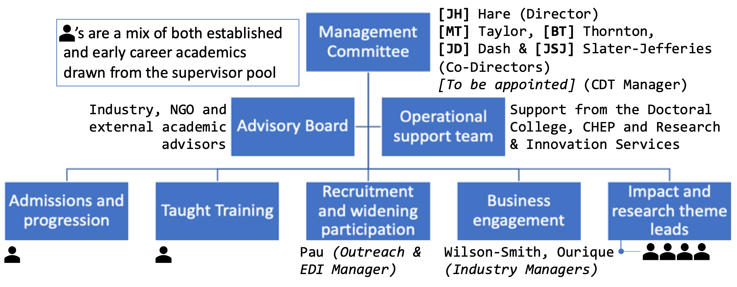
Our team is built on diverse skills needed to deliver this highly interdisciplinary proposal, with experienced members to ensure successful initial programme delivery, and succession planning for the team to evolve during the CDT lifecycle with junior colleagues stepping up as they gain experience. Director JH is an expert in ML with publications in top venues (e.g., prestigious NeurIPS and ICLR papers), with collaborations in Geospatial AI across the University. His >15-year collaboration with OS has funded PhDs & projects, resulting in publications in top journals on using ML with geospatial data, a joint patent8 and transformative business changes at OS9. The management committee (MC) offers leadership ability, experience in developing successful postgraduate training, successful PhD supervision, quantifiable academic excellence in the four CDT themes, and comprehensive relationships with industry. Highlights: JH is Deputy Head of School (DHoS) Education and former Director of both UG and PhD programmes; MT is Head of School, previously DHoS Research, and member of the UoA10 REF panel; JD is founder of Southampton Geospatial, co-chair of the ESRC IAA and a former DHoS Research, faculty Director of Enterprise, and MSc Programme lead; BT co-directs the In Situ and Remote Intelligent Sensing centre and was EPSRC Fellow for Marine Robotics and AI, with established collaboration with the NOC in EPSRC and NERC remits; JSJ is CEO of the National Biofilms Innovation Centre and former Associate Dean. Collectively they have supervised >50 PhDs to completion. Subcommittees on student admissions and progression (AP); taught training (TT); recruitment, outreach and widening participation (ROWP); business engagement (BE); impact and research themes will report to the management committee (IRT). Each of the four CDT themes has an aligned IRT lead. ROWP is led by an experienced outreach manager and EDI champion who will manage outreach and public engagement, develop and monitor recruitment, and support mechanisms to embed EDI in our cohorts, supervisor pool, management, and operations. AP supports students using evidence-based approaches such as mentoring and coaching and provides pastoral care aided by central university support. Each subcommittee will be coordinated by a member of the management committee, working with academic and support staff across the CDT. Students and partners will be on subcommittees, enabling contributions throughout. BE is led by existing managers with large portfolios of connections. An advisory board will guide the CDT and a dedicated manager will lead operations, overseeing support throughout. The CDT follows university good practices, including having at least two supervisors per student and mandatory EDI training for staff and students. Our initial engagement has identified a pool of 56 potential supervisors (30% ECR, 34% female) across all faculties and CDT themes to work alongside co-supervisors from partner organisations. We aim to achieve a supervisor profile with 50% ECR and 50% female within the first 3 years of the CDT with help from our institutional EDI working group and strategy10.
References: 1Fortune Business Insights; 2UK Geospatial Strategy 2020-25; 3National AI Strategy; 4National Resilience Strategy; 5National data strategy; 6HM Treasury Spring Statement 2022; 7AI Council AI Roadmap; 8UoS-OS Patent GB2559566; 9UoS REF2021 ICS11-06; 10UoS EDI Strategy